

It is in Glenn County, 19 miles northwest of Willows on State Highway 162. It is between -122°30'00" and - -122°22'30", and 39°29'53", 39°37'23". Other: Glenn county FIPS: 06021. California FIPS: 06. Area code: 530. GMT: -8.
According to Glenn County Place Names, Fruto’s name stems from the fruit orchards of the area. Others are not as certain how the name originated. Before the town was laid out there was a railroad line with a terminus called Fruto and also a nearby company called the Fruto Land Improvement Company. The word “fruto” does not mean fruit. It means produce.
1878
The Northern Railroad reached Willows 26 September 1878.
1884-1888
In 1884 plans began for a branch railroad from Willows to the coast by way of Elk Creek and Grindstone canyon. The hope was that the railroad would take advantage of the great fruit and wool growing in the county and on the coast range the sugar pine and redwood lumbers. That would bring mills to Willows.
1886-1887
On October 26, 1886 Turon & Knox of Sacramento was awarded the contract for grading the new branch[i]. The wooden-wheeled scrapers were pulled by mule power. The scrapers hung from the wheel axle and they were tipped up to hold the dirt while the wheels carried the dirt to its destination. In April 1887 the grading was about completed and track laying began in March 1888. This work was done by Chinese labor[ii].
1888
The Westside and Mendocino Railroad Company tracks reached the future site of Fruto in 1888. Fruto was the last of five stops. The fourth was Athena, at mile 1/4 west of Willows (appeared in Southern Pacific timetables printed in the 1890s). The third was Millsholm, named for Edgar Mills when the spur to Fruto was built through his land in the 1880s. "Holm" is German for "hill" and this former railroad siding was located in the foothills 10 miles west of Willows.
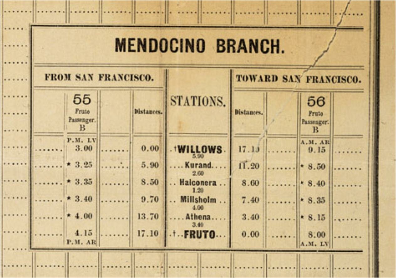
Excerpt from Joint Time Table #4 of Southern Pacific Company. Benicia Division, Clear Lake Division and Mendocino Branch dated 5 Sep 1888.
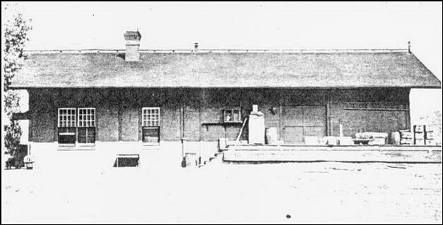
Near the Fruto depot were cabins for workers. The railroad built a depot with living facilities for the station agent, offices and a freight storage area. The Company erected a water tank atop a tower. It constructed a roundhouse, warehouses for grain and hay, corrals and loading platforms for cattle, sheep and hogs. It planted palm trees and even made a small park beside the depot.[iii]
The passenger train made a daily morning trip to Willows, returning in the afternoon. At the same time, a freight train originated left Willows and returned in the afternoon. The employees were J. O. Thrower, conductor; A. Frisbie, engineer; and Charley Wickes, fireman[iv].
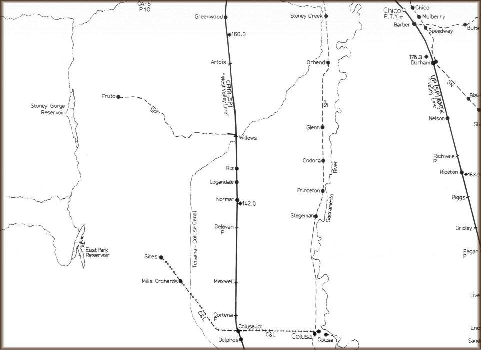
Fruto Willows area railroad lines – “Railroad Atlas of North America, California and Nevada”,
MikeWalker, Steam Powered Publishing, Dawes Road, Dunkirk, Faversham, Kent, UK, 1994. Used with permission.
Fruto roundtable
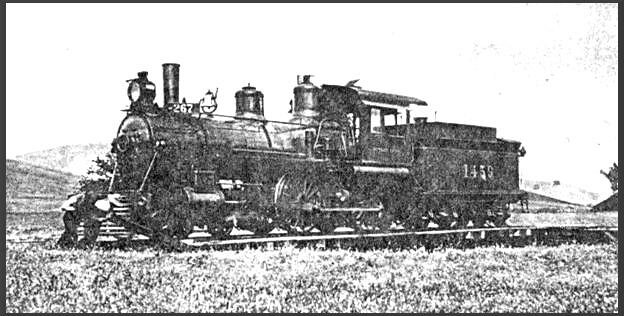
Originally published in "Wagon Wheels", used with permission.
Fruto depot
[The train depot was destroyed by fire in the 1950s and the site is now privately owned. The trees in the photos below are still there and mark where the depot stood. Not far away are pieces of a railroad spur and the old machine shop now used as a barn. Nothing else remains.]
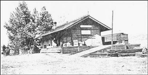
Originally published in "Wagon Wheels", used with permission.
Originally published in "Wagon Wheels", used with permission.
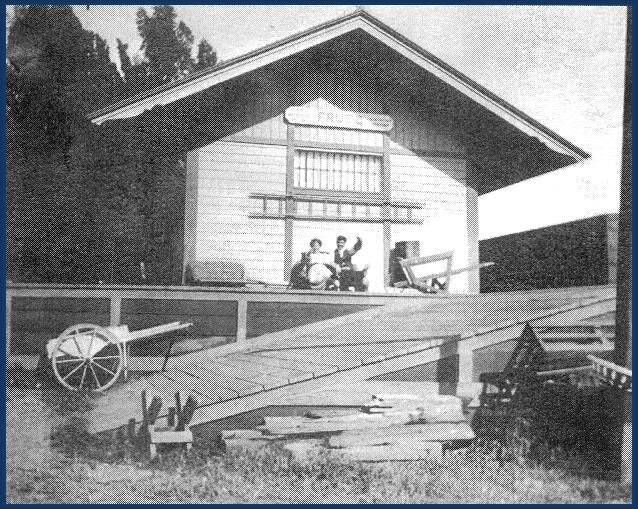
End of the Fruto depot with Hardy "Harlie" Haskell and his wife Pearl.
Tom Haskell Collection originally published in "Wagon Wheels", used with permission.
1888
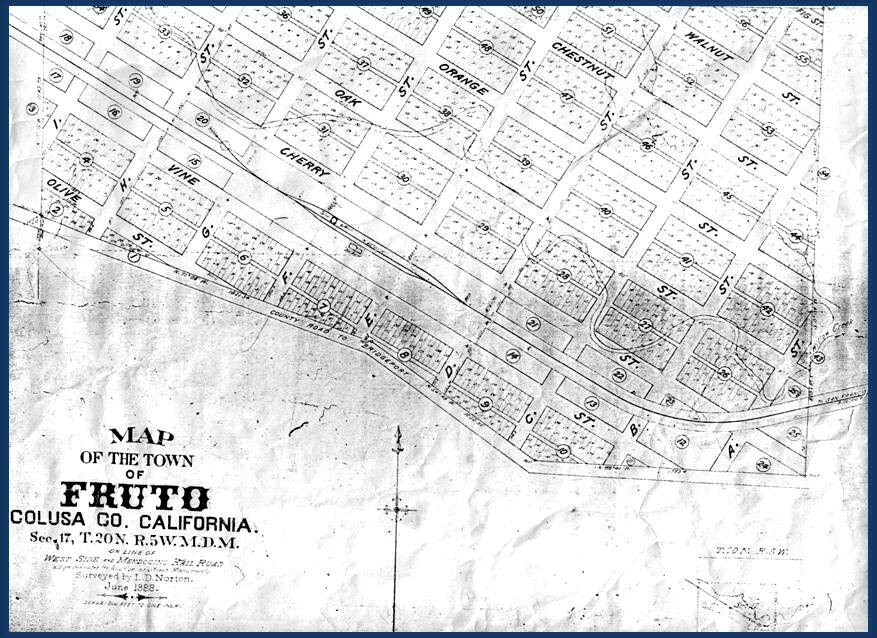
By May 28, 1888 the real estate firm Easton Eldridge and Company of San Francisco had laid out town lots at the terminus and were running special trains from San Francisco to bring prospective buyers to Fruto[v]. The town was laid out with northeast/southwest alphabetical streets A through I intersecting southeast/northwest streets Olive, Vine, Cherry, Oak, Orange, Chestnut, Walnut, and Fig. [In 2003 the only streets still in use are B Street south of Vine and D, G, and Cherry Street north of Vine. The C, G, and Cherry loop is commonly called Cherry Street. Vine Street is now State Highway 162. None of the other streets were ever developed.]
Map of Fruto, June 1888
The post office was established on July 2, 1888, and ceased operation on August 15, 1953. [All the streets now are part of the Willows, California postal destination. Fruto is no longer a valid mail address.]
According to John Williams and his article on California Town postmarks, the Fruto postmark indicated Fruto, Colusa county from 1888 to 1891 and beginning in 1891 Glenn county.
Doane Cancels were the Post Office Departments first attempt to improve postmark legibility by issuing rubber hand stamps. The name honors Edith R. Doane a Postal Historian who became interested in these early 20th Century Hand stamps in the 1950's. She published her first research findings in 1978. The Fruto Post Office used the Type 2 cancels with 2 sets of railroad track type bars with a number in them. The cancel was used from 30 Sep 1904 until 4 Apr 1909. In the entire United States approximately 17,500 Type 2 Doane Hand stamps were issued.
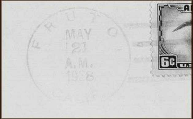
Fruto Postmark from May 21, 1938
1890
The 28 January 1890 edition of the Woodland Daily Democrat reported that “a number of Japs went north today to Fruto to work in the vineyards.
The 19 June 1890 Woodland Daily Democrat reported that the Clark’s Valley ranch of Senator John Boggs, comprising 13,000 acres situated near Fruto had been acquired by a San Jose syndicate, the Cornall-Futzhugh-Hopkins Company. The land would be handled as a whole or in subdivision and offered at from $20 to $50 an acre.
1891
The county begins to issue death certificates. Before this date, deaths in the county were not recorded.
Considerable produce was being shipped from Fruto. It had a depot building, hotel, dance hall, saloon, general store, post office, and telegraph office. The Argonaut Land Company owned about 10,000 acres adjoining the town and was improving it and subdividing it into small tracts. Because the railroad tracks were in the center of town, commercial establishments were built on the south side (Vine Street) and the residential development occurred on the north side (Cherry Street).
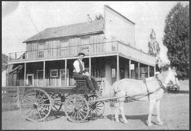
Hotel. Used until about 1915 and then converted to a home. Destroyed in a fire.
Tom Haskell Collection originally published in "Wagon Wheels", used with permission.
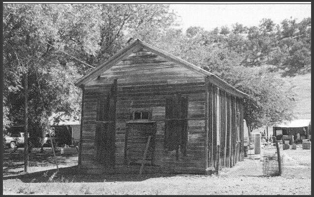
The Saloon. Photo courtesy of "Wagon Wheels", used with permission. Still standing 2004.
Blacksmith shop, store, and house originally the home of the teacher moved here from near the schoolhouse 1918-1919.
Tom Haskell Collection originally published in "Wagon Wheels", used with permission.
The Fruto Land and Improvement Company purchased 3,000 acres of land near Stony Creek with the intention of planting 250 acres of raisin grapes. An acre of raisen (sic) grapes will yield, when in full bearing, from two to three tons of raisins which are sold to the packers at about $90 ton, thus giving the a handsome return to the producer. The leading variety of raisen grape is the Muscat of Alexandria, otherwise known as the Muscatel[vi]. The Land Company dug a 6 mile irrigation ditch from Stony Creek to their land and used it for irrigating alfalfa.
1892
The Woodland Daily Democrat edition for April 11, 1892 reports that a locomotive that runs on the Fruto branch road passed through Woodland bound for repairs at the machine shop in Sacramento.
1893
The Woodland Daily Democrat for 27 July 1893 reported that Rev. J. C. Pulliam left that day for Fruto where he was spending his vacation.
1895
In the 1895 Atlas, Fruto is listed in Glenn country, with a post office, railroad, and express office.

1895 Map of Glenn County
1898
A Wagon Wheels article[vii] on the Westside and Mendocino Railroad relates this story: In 1898 the Northern Railway Company was acquired by the Southern Pacific and became a part of the great S.P. system. Not long after a strike was called by the operational and maintenance employees of the Southern Pacific. An interesting story of the part played by the little Fruto line in this strike was told by Clarence Wickes, son of Charley the fireman on the line, in his column “Wixie’s Recollections”. He wrote, “….the strike against the Southern Pacific tied up every wheel on the system except the Fruto branch which the strikers overlooked, so it continued on its regular runs. The Southern Pacific Company cancelled the seniority rights of the employees who took part in the strike, stirring up a very bitter fight that had the marks of a riot at Sacramento and Dunsmuir. . . . . The Governor called out Company G of the National Guard at Willows to be ready to protect the company property. At this point the strike was called off. The S.P. Company rewarded the Fruto crew with the high seniorities lost by the strikers. Thrower and Frisbie were given high rank and Wickes was called to Sacramento and promoted to engineer which was unusual at his age.”
The California Blue Book or State Roster was published. It has two Fruto residents: G. F. Behrens was a Notary Public in Fruto and J. O. Thower was on the Board of Agriculture for District 42.
1900
1900 U.S. Federal Census. The U.S. Federal Census enumerator doesn’t indicate on his census schedule where Fruto begins and ends or street/road identifications. This caused some difficulty in making sure the biographical section bellows included all the residents. Some names are probably missing. The best I could do was take the names on the 1910 through 1930 listings and try to find them in 1900. I found some in the third judicial township and some in the fourth.
1902
In 1902 there was a grammar (elementary) school in Fruto. The teacher was H. G. Rawlins[viii]. The school was a one-room affair and included grades 1-8. Another teacher was Kat Frasier.
1910
1910 U.S. Federal Census. The U.S. Federal Census enumerator listed the families and identified those on Vine and Cherry Street. The heads of households in 1910 were: George Prentice, Charles Schmidt, Edwin Bunnell/Burnell, John Zumwalt, David Pelton, Mabel O’Brien, and Frontier Parsons.
1914
On 20th of September, S. H. Rice publishes his “Rice’s Official Map of the County of Glenn, State of California”. Fruto has platted streets. There is only one road in and out of the town, the current County road 162.
1917
During World War I and also WWII the train carried chrome ore or chrome concentrate from the mines west of Chrome to smelters in the Bay area.[ix]
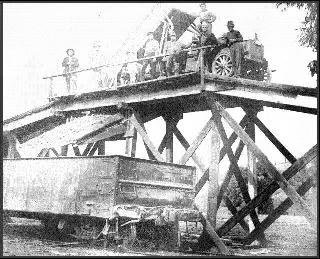
Ore truck from the mine at Chrome dumping ore in railroad card.
Tom Haskell Collection originally published in "wagon Wheels", used with permission.
By 1917 copper ore from the Frank Tendor copper mine between Stonyford and Fouts was being trucked to the railhead at Fruto.[x] But activity at the station was slowing. The resident agent was eliminated and the station was closed.
1920
1920 U.S. Federal Census. The map used to determine the enumeration districts was Rice’s Official Map of the County of Glenn State of California, published by S. H. Rice in 1914. The U.S. Federal Census enumerator did not indicate on what streets the families lived. The heads of households in 1920 were: William Shields, Andrew Davis, Frontier Parsons, Richard Bedford, Ammiel Landberg, Paul Thomassen, John Haskell, Jesse Haskell, James Cronin, Douglas Crum, Joe Perry, Oscar Lyon, Dryden Garnett, William Hudson, Louis Bonne, John Campbell, John Soeth, and Frank King. The only commercial activity appearing in Business and Credit Directories is the business of A. Landberg[xi]. His general store business is small, the estimated financial strength is $5,000 to $10,000, and his credit rating is fair. [The store building (square, corrugated metal) is still standing in Fruto.]
1923
Fruto has a population of 58. Its residents must go to Willows for banking services. A. Lanberg is still the only business being credit rated.[xii].
1927
The Fruto station is re-opened and a resident agent is assigned in order to accommodate the shipment of dam materials for the Stony Gorge Dam, Orland Project. The dam materials were shipped out on the Fruto line and then to the dam site 12 miles away. The dam, 5 miles west of Fruto, was completed in 1928, a concrete slab and buttress structure with a height of 139 feet and a crest length of 868 feet. Behind it is a fishery with 18 miles of shoreline and boating and camping facilities.
The spur was also used to ship cattle to market. Southern Oregon ranchers partnered with Fruto area ranchers grazing their cattle in Oregon in the summer and around Fruto in the winter. The cattle were penned on the outskirts of Fruto before loading onto trains. The pen area was triangle shaped on the west part of the town and extended the length of the town on the north. All the properties on the north side of Cherry Street have a 30-foot easement that was part of the route from the pens to the loading dock.
1930
1930 U.S. Federal Census. The map used to determine the enumeration districts was Rice’s Official Map of the County of Glenn State of California, published by S. H. Rice in 1914. The U.S. Federal Census enumerator simply indicated that all the residents were on Willows Fruto Road. The heads of households in 1930 were Amiel Landberg, Jesse Haskell, Irvin Larabee, Samuel Larrabee, Thomas Sheehy, Raymer Garnett, Warren Larrabee, Floyd Vaughn, Richard Nichols, Elmer Mudd, Frank Green, Samuel Stormer, Sylvan Stormer, Frank King, Oscar Pitzer, Worthy Vanderford, Richard Bedford, Charles Bedford, Louis
1948
The Glenn County Directory lists these heads of families in Fruto: Albert Campbell – farmer; Jesse Haskell(Bessie) – watchmaker; Thomas E. Haskell(Adrienne) – laborer; Mrs. Josephine King – farmer; George Roeth – farmer; Robert L. Spence(Cleo) – grocery and exchange; and Carl Studebaker(Bertha) – laborer.
1951
In 1951 the branch railroad tracks to Fruto were removed with the exception of a one-mile section west of Willows. This was the new terminus and it handled wood products produced in the Setzer Box Company mill in Elk Creek.
1959
The one-room school closed after 1969. The last teacher was Mrs. Marie Farrell. The students were sent to Elk Creek or Willows depending on where they lived.
2004
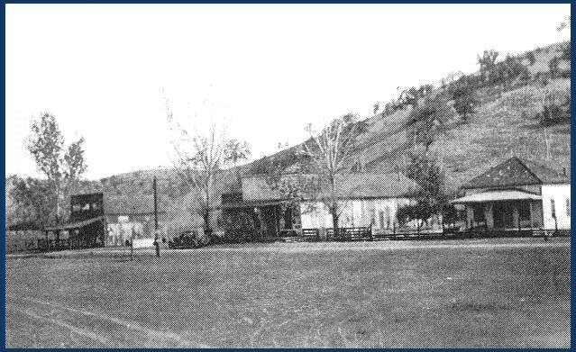
There are no longer any stores or occupied commercial buildings in Fruto. The railroad machine shed is now a barn, the saloon building is long abandoned, and the school is a private home. There are ten homes in town of which three are historical – the former elementary school, the home of Tom Haskell, and the home and workshop of his father Jesse Haskell the watchmaker.
Fruto itself did not have a graveyard. Most people were interred in Elk Creek. However, Tom Haskell, a long time resident” related this story in 2004. “I could another little piece of history you can put in the article but some may not be good to advertise tho some I know would get a kick out of it. Fruto had a graveyard. A man was buried there. No one seems to remember his name. When I showed Mr. Frank King Sr. where the grave was he put a small hog brooder house on top of it. I haven’t seen the spot for years but once there was a little depression there. The spot is close to where a man built a small reservoir in the creek and digging up dirt to make the dam he rooted out lots of Indian bones.” “In about 1913 the train brought my great aunt out from Willows. There was very little gravel on the roads in those days. But when the big black hearse from Elk Creek loaded her on, it was all four big black horses could do is pull over the divide from here to Elk Creek.”
Who was the first child born in Fruto? Leonard Landberg has stated that he was. But another resident, Tom Haskell, believes otherwise. This is what Tom says: “I just learned a few years ago he (Leonard) said he was the first born in Fruto, the store keeper…. His folks at the time ran the store. I’ve no idea if they owned it or just run it a while. But when the eventful day came the Dr. from Willows came out (I can’t recall his name now). But it was a hot day. They rented a horse or maybe I should say team (I wasn’t here) and drove to Alder Springs. There was a hotel and store there. In mountain air, a lot cooler. I was the first born in Fruto. When the fated day came, Dr. C. W. Lund boarded his Cadillac roadster to make the trip from Willows. The road had been recently graveled so the vibrations put out his curbside lights. He stopped at the Millsholm railroad depot, borrowed a kerosene lantern and hung it on his radiator cap. Got here just in time. Several in the neighborhood, with the railroad crew, were in the card parlor, the saloon playing cards when the stork went over. ….. I may be the only child in history I know in Fruto.”
Who lived in Fruto? I have tried to document everyone who lived in or near Fruto from its beginning until 1930, that person's parents, and that person's children. For privacy reasons I have tried not to include details on living people. (Click here to go directly to the individual or surname indexes.)
Last update 10 February 2005
[i] Colusa County, Op cit.
[ii] Wagon Wheels, Colusi County Historical Society, Volume XX, Number 1, 1970, The Westside-Mendocino Railroad, author unidentified, p. 21.
[iii] Wagon Wheels, Colusi County Historical Society, Volume 52, Number 2, Fall, 2002, Fruto Still Exists, Richard Johnson.
[iv] Ibid.
[v] Wagon Wheels, Colusa County Historical Society, Volume XXXV, Number 1, 1985, Schools of the Past by Sybil Spence Hicks, p. 12.
[vi] Colusa County, Its History traced from a state of nature through the early period of settlement and development to the present day, Justus H. Rogers, Orland, California, 1891.
[vii] Ibid. pps. 21-23.
[viii]Schools of the Past, Op cit., p. 12.
[ix] Wagon Wheels, Colusi County Historical Society, Volume 52, Number 2, Fall, 2002, Fruto Still Exists, Richard Johnson.
[x]Wagon Wheels, Colusa County Historical Society, Volume XXX, Number 2, 1980, Copper Strikes Caused Stampede to Indian, Bear Valleys in 1863 by Robert L. Johnson, p. 18.
[xi] Businesses, Manufacturers, Merchants and Tradesman for Glenn County, California 1920, compiled from the R.G. Dun Mercantile Agency Reference Book and published by Aaron’s Books, 146 South Broadway, Salem, Ohio, no publication date.
[xii] Businesses, Manufacturers, Merchants and Tradesman for Glenn County, California 1923, compiled from the R.G. Dun Mercantile Agency Reference Book by Carl Millison Jr., published by NSN Books Genealogy and Sewing Shop, March 2003.
[xiii] Ancestry.com. California Death Index, 1940-1997. [database online] Provo, UT: Ancestry.com, 2000. Original electronic data: State of California. California Death Index, 1940-1997. Sacramento, CA: State of California Department of Health Services, Center for Health Statistics, 19--.
[xiv] Ancestry.com. California Death Index, 1940-1997. [database online] Provo, UT: Ancestry.com, 2000. Original electronic data: State of California. California Death Index, 1940-1997. Sacramento, CA: State of California Department of Health Services, Center for Health Statistics, 19--.
[xv] “The Chinn and Meyers Families”, Randie Myers, Ancestry.com FamilyConnect.
[xvi] Ancestry.com. California Death Index, 1940-1997. [database online] Provo, UT: Ancestry.com, 2000. Original electronic data: State of California. California Death Index, 1940-1997. Sacramento, CA: State of California Department of Health Services, Center for Health Statistics, 19--.
[xvii] California Cemetery Records Glenn County 1940-1970, Sacramento Valley Chapter Daughters of American Colonists, compiled by Mrs. F. Joseph Watts, Chairman Genealogical Records Committee.
[xviii] Ancestry.com. California Death Index, 1940-1997. [database online] Provo, UT: Ancestry.com, 2000. Original electronic data: State of California. California Death Index, 1940-1997. Sacramento, CA: State of California Department of Health Services, Center for Health Statistics, 19--.
[xix] Marcus and Mary’s information is in California Cemetery Records Glenn County 1940-1970, Sacramento Valley Chapter Daughters of American Colonists, compiled by Mrs. F. Joseph Watts, Chairman Genealogical Records Committee.
[xx] Ancestry.com. Yuba, Sutter, Colusa, Butte, and Tehama Counties, California Directory, 1885. [database online] Provo, UT: Ancestry.com, 2000. Original data: Yuba, Sutter, Colusa, Butte, and Tehama Counties, CA, 1885. Oroville, CA: L.M. McKenney & Co., 1885.
[xxi] Social Security Death Index.
[xxii] California Cemetery Records Glenn County 1940-1970, Sacramento Valley Chapter Daughters of American Colonists, compiled by Mrs. F. Joseph Watts, Chairman Genealogical Records Committee.
[xxiii] California Death Index.
[xxiv] Mainard family information from Patti Oakley McFarlin “Our Family’s Heritage” at www.ancestry.com.
[xxv] 1850, 1860 Linn County Missouri Census Project, electronic database at worldconnect.rootsweb.com, compiled by Jeff Bailey (), 18 December 2003.
Didn't find what you were looking for? Try searching this site.
Most recent update 31 Aug 2004Send email to brian at brianbonner dot net